

Software
Services
Products
About Us
Contact Us
Cart


Looking for a simple,
cost-effective software platform?
MasterSuite combines Asset Management, GIS, & Work Maintenance. Quick analysis for grant funding, liability, agency cost, asset age, work history, and much more!
Create customized reports on your asset attributes.
Example: generate Horizontal Curves with advisory speeds under 30 mph
Online and/or Offline use on tablets, laptops, and desktop PC’s
One (1) overall Annual Maintenance Agreement
fee covers All modules (No separate fees per module) and is optional
Virtual DMI (Distance
Measuring Instrument): No
more copying and pasting GPS coordinates nor milepoints
esri® Basemap layers: High quality aerial photography
along with street maps which serve as background for your assets
Measure distance with our
easy to use aerial based measuring tool. Example: measure a guardrail
distance from the roadside
Security: User accounts with Administrative or Read-Only rights to ensure data security
Easily export all of your
asset data to Excel
Import GIS Layers: Utilize exported GIS layers from esri® ArcMap for Online
or Offline use
SHARED FEATURES


RETURN TO TOP

Easily view, search, and
map all your traffic signs. Example: map all low reflectivity stop signs
Mobile Mapping imagery can be linked to all traffic signs
Document, track, and
report exactly what work
was performed. Who, what,
why, when, and where.
Easily document, track, and
run reports for all inspections
Track all signs retro-reflectivity
to better meet all FHWA based retro-reflectivity requirements
as listed in the MUTCD
Quickly take photographs
of your traffic signs with
any attached camera
Add, edit, and delete dictionary items including: Sign face material, work reason, post material, etc.
Easily adjust your GPS coordinates without ever leaving your vehicle
Displays all traffic signs
within a designated
proximity of your GPS
location
SOFTWARE OVERVIEW
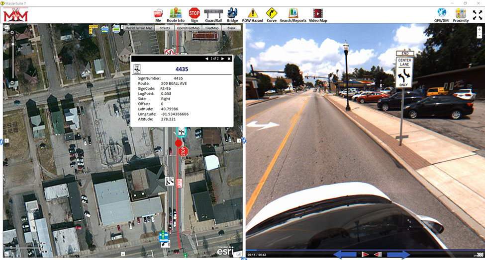
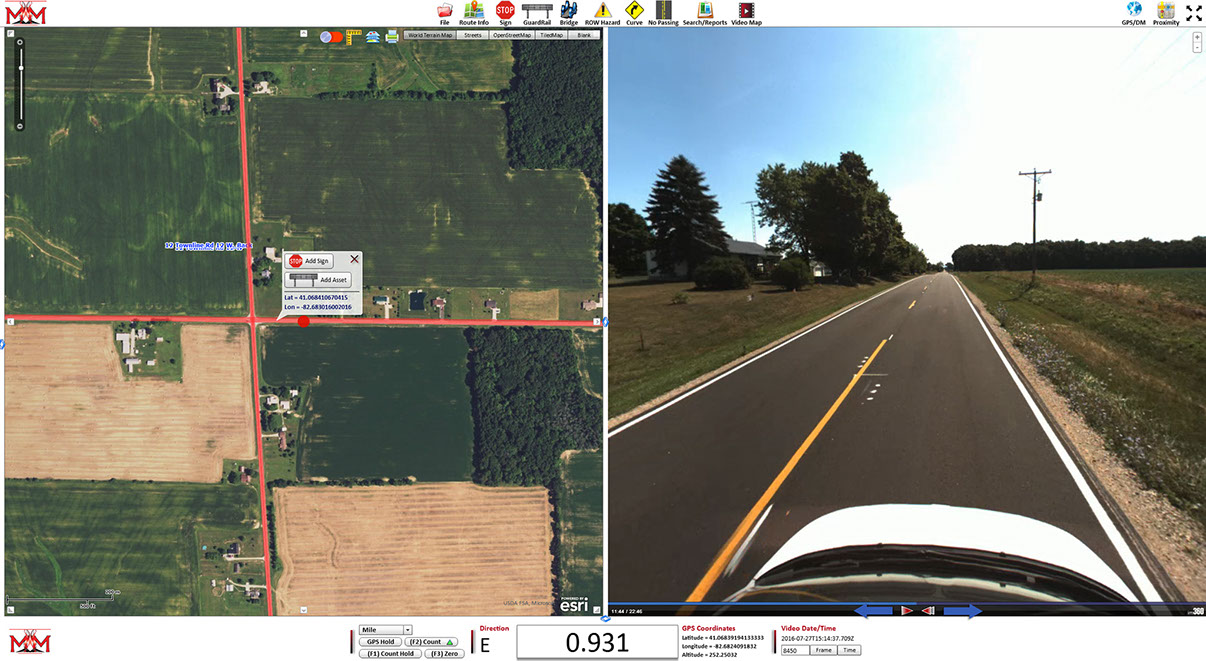
SignMaster is our easy to use software module
that allows you to inventory, manage, budget,
and review all of your traffic sign data.
SignMaster allows in-field inventorying and
inspection as well as office-based post-processing.
Track many attributes
such as: GPS, milepoint,
face material, support
type, ADT, reflectivity
strips, costs, dates, etc.
Comprehensive signcode dictionary that includes all MUTCD traffic signs, each
with graphic representation and signcode
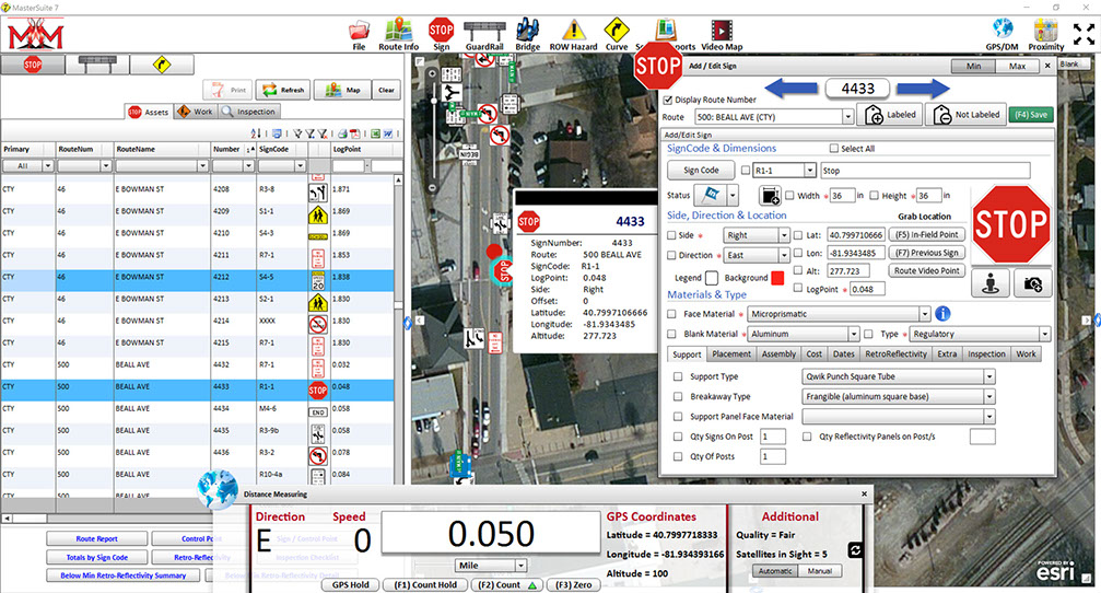
Easily grab and move any sign on the GIS map which automatically updates GPS coordinates
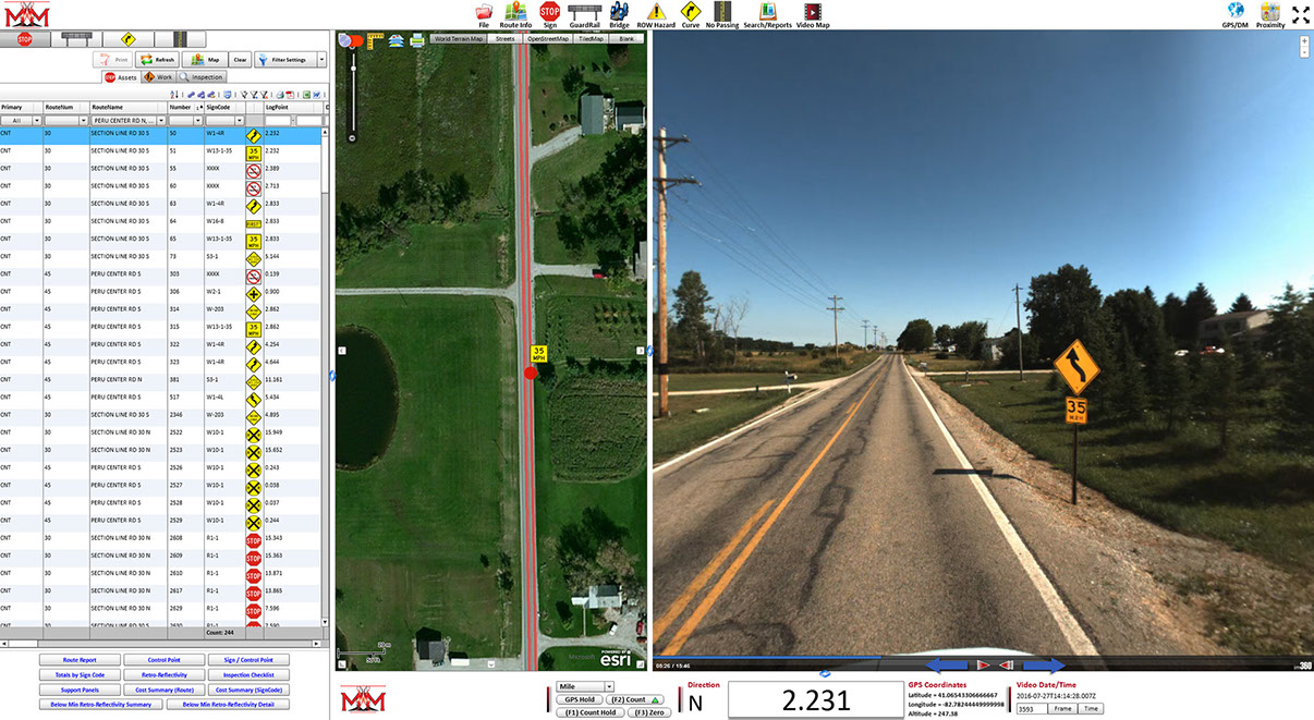
SignMaster allows you to add, edit, and delete signs, search reports, map signs, and use a LocationMaster (virtual DMI).
SignMaster allows you to search reports using filters. Ex: Filter on all signs with a below minimum reflectivity.
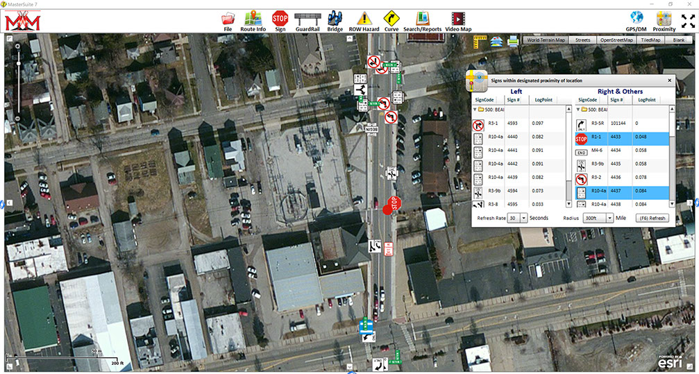
SignMaster allows you to view all signs within your proximity as you move.
SignMaster allows you to view your routes, control points, and signs for the highlighted route at the same time.
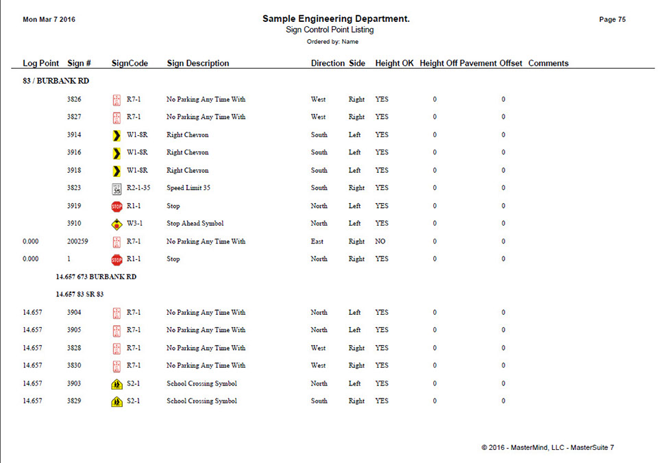
SignMaster includes many customizable reports as well as template-based reports, such as this Sign Control Point Report.


<
>
1 - 5
FEATURES

SOFTWARE OVERVIEW
CurveMaster allows you to record and map all horizontal curves, record ball bank pass details, inventory in-field curve signage, and propose
required curve signage for compliance with the
FHWA December 31, 2019 Horizontal Alignment Warning Sign Deadline. CurveMaster allows
analysis for all horizontal curve and curve signage
data by way of grid, mapping, and reporting.
• CurveMaster can be purchased as a stand-alone comprehensive package or a supplementary
software with the curve study performed by MasterMind, LLC.


RETURN TO TOP
Easily view, search, and map
all your curve data. Example: map all curves with advisory speed below 30 mph
Mobile Mapping imagery can be linked to all curves and curve signs
Document, track, and
report exactly what work
was performed. Who,
what, why, when, & where.
Allows agency to be in compliance with FHWA December 31, 2019 Horizontal Alignment Warning Sign deadline
Track many curve attributes: point of curvature (POC), point of tangent (POT), apex, GPS, advisory speed, acting speed, direction, status
Allows in-field recording for ball bank pass details of each curve
Easily adjust your GPS coordinates without ever leaving your vehicle
Color coded GPS mapping
for all curves based on advisory speeds
Automatically determine your required curve signage based
on MUTCD specifications
Stand-alone package allows
your agency to internally complete the 2019 FHWA Horizontal Alignment
Warning Sign mandate
Easily grab and move any
curve sign on the GIS map which automatically updates GPS coordinates
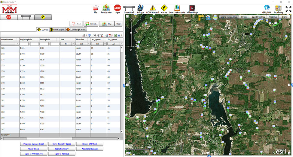
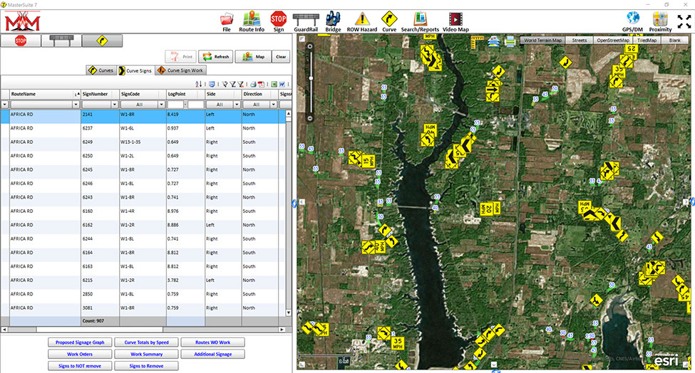


CurveMaster allows you to view all of yur curve data in map and grid form simultaneously.
CurveMaster allows you view all of your in-field curve signs.
CurveMaster allows you to search and filter for a specific route and its associated curve signs.
CurveMaster allows you to view all curve sign work details.
CurveMaster includes many customizable and template-based reports, such as this graphical report displaying proposed signage, curve groupings, and control points.
<
>
5 - 5
Graphical report displaying curve and proposed signage details
FEATURES


RETURN TO TOP

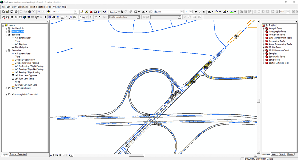
SOFTWARE OVERVIEW
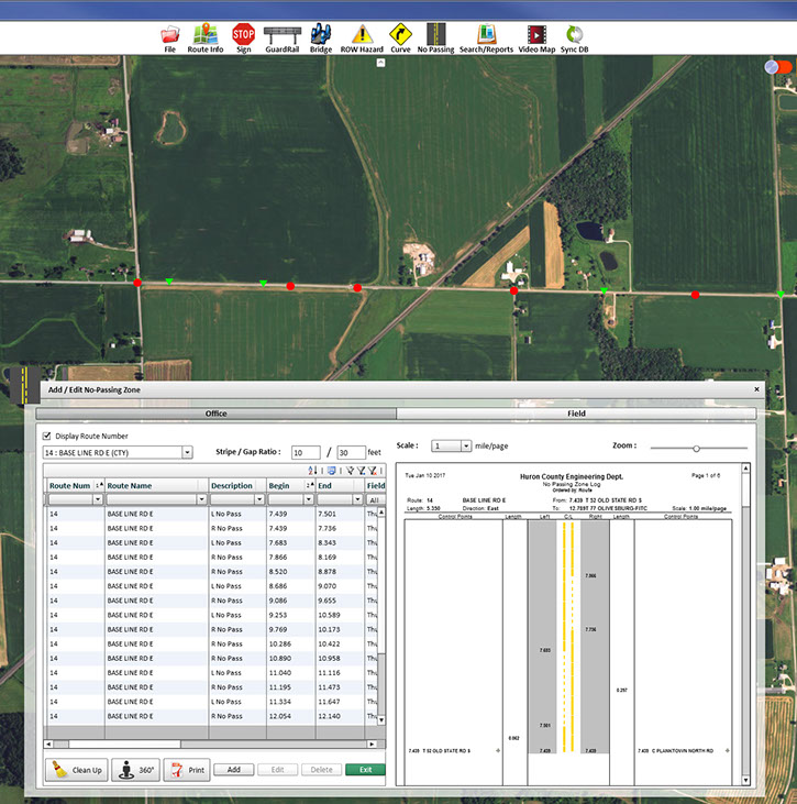
StripeMaster allows you to manage your centerline striping No-Passing Zones, making your roadways
safer for the traveling public. With StripeMaster
you're able to view your No-Passing Zones by way
of our graphical reports and GIS mapping.

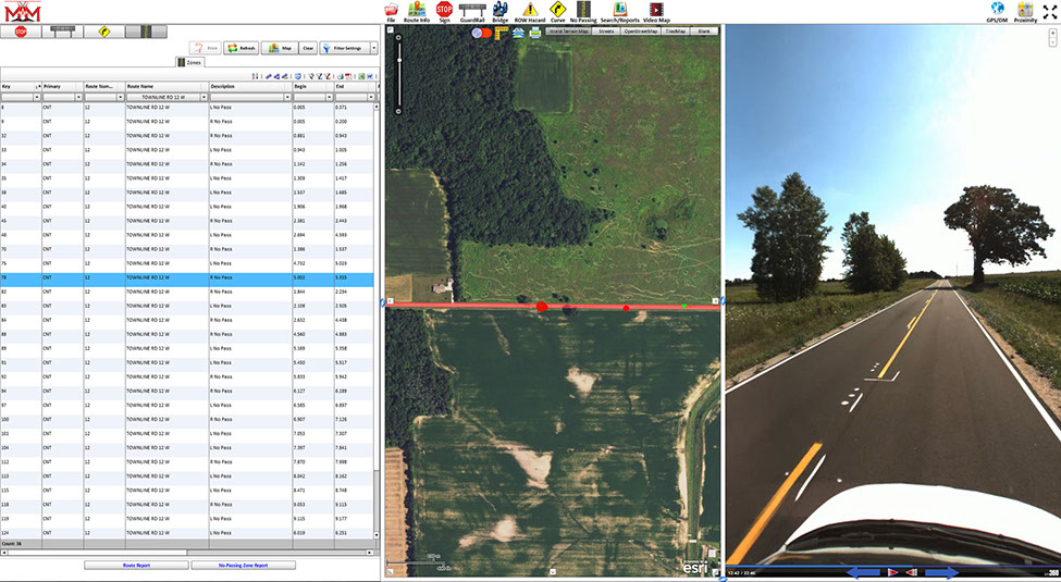

StripeMaster allows you to simultaneously view your no-passing zones using GIS mapping and reporting.
StripeMaster allows you to search a specific route, map the route, and view the no-passing zones with a 360° view.
StripeMaster allows you to measure your no-passing zones with a built-in virtual DMI.
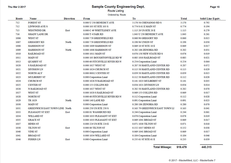
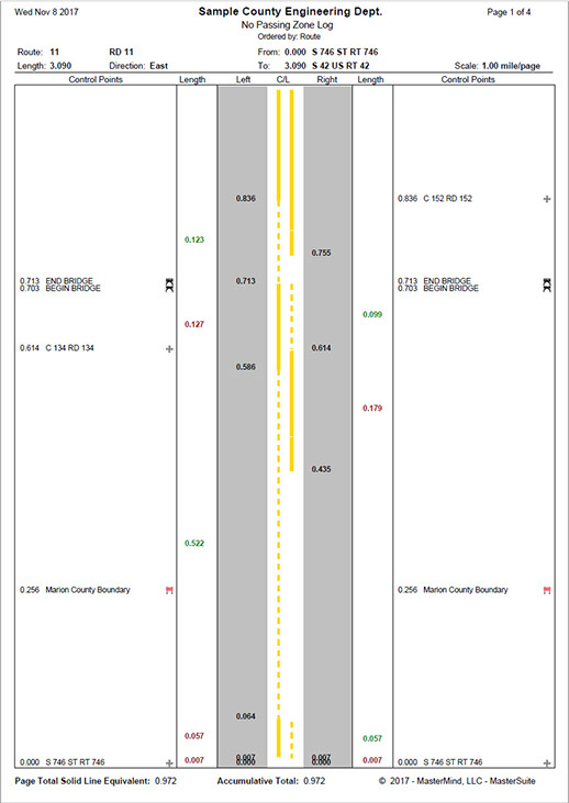
StripeMaster includes multiple template-based reports, which includes this route report to show your solid line equivalent for paint estimations.
StripeMaster includes multiple template-based reports, which includes this graphical report displaying centerline striping.
<
>
5 - 5
Easily view, search, and map all your centerline No-Passing Zones. Example: view a specific No-Passing Zone for easy T-Marking
Mobile Mapping imagery
can be linked to all
No-Passing Zones
Manually adjust "stripe to gap ratio" for your reports to meet your agency requirements
Graphical report display solid line totals per section and per road, allowing lineal footage, paint, and bead quantities to
be calculated
Route report displays the accumulated solid line per route, allowing lineal footage, paint, and bead quantities to be calculated
Side by side grid and PDF preview of your zones for in-depth review
T-Marking & road indexing
can be easily achieved by utilizing the graphical
reports and visually represented GIS mapping
Automatically correct and adjust your zones with the click of a button to better meet required zoning laws
Manually edit your zone attributes such as: route,
zone type, description, field
date, GPS, as well as
beginning and ending
milepoint
FEATURES


RETURN TO TOP
SOFTWARE OVERVIEW
MarkingMaster is our easy to use software module
that allows you to locate, track, view, budget, and maintain your auxiliary and long line (center line,
edge line, etc) pavement markings . MarkingMaster allows in-field inventorying and inspection as well
as office-based post-processing.

Easily view, search, and
map all your auxiliary markings. Example: map
all left turn arrows
Mobile Mapping imagery
can be linked to all
pavement markings
Document, track, and report exactly what work was performed. Who, what, why, when, and where.
Easily document, track, and run reports for all inspections
Quickly take photographs of your pavement markings with any attached camera
Add, edit, and delete dictionary items including: condition rating, cost, material, type, etc.
Easily adjust your GPS coordinates without ever leaving your vehicle
Track many attributes such as: route, GPS, milepoint, material, type, condition, cost, years striped, etc.
Easily grab and move any auxiliary
marking on the GIS map which
automatically updates GPS coordinates
MarkingMaster pictures coming soon!
<
>
1 - 1

FEATURES

RETURN TO TOP
SOFTWARE OVERVIEW
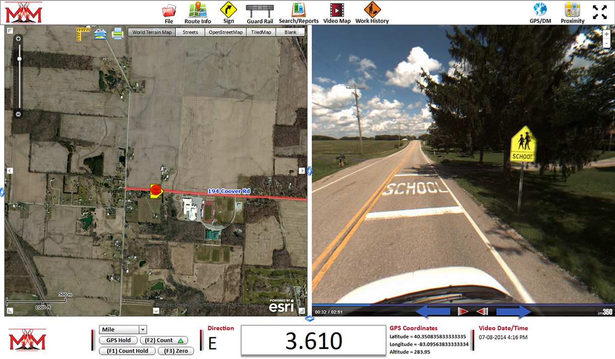
VideoMaster allows you to map and view your
mobile (video) mapped roadways. VideoMaster
allows you to view all of your traffic assets and roadways in 360° high definition videos.

Virtually drive your routes and measure distances inside the mobile mapped video using built-in distance measuring instrument (DMI)
View 360° high def imagery
of roadways & assets from
the comfort of your office
Each mobile mapped video is time and date stamped
Each videoed route is mapped overtop orthographic imagery allowing any route location to be clicked and displayed at street level
Seamlessly drive your route instead of having to click forward & backward, waiting
for an updated image
Extract GPS coordinates and mile point from any videoed location
Virtually drive a route inside
our 360° high definition video
to view your pavement
markings, traffic signs,
roadway hazards, and more
Saves time and money from sending out crews for observation and measuring
Virtually drive any videoed
route forward & backward
VideoMaster provides you a virtual DMI to drive your routes, viewing any asset on a specific route with a 360° view. Ex: View a traffic sign within a school zone.
VideoMaster allows you to view a mapped route and zoom in on your asset with a 360° view.
VideoMaster allows you to view any asset within a mobile (video) mapped route. Ex: View your guardrail with a 360° view.
VideoMaster allows you to view any asset within a mobile (video) mapped route. Ex: View a T-marked route with a 360° view.
VideoMaster allows you to view any asset within a mobile (video) mapped route. Ex: View your curves and associated curve signs with a 360° view.
<
>
5 - 5
FEATURES

RETURN TO TOP
SOFTWARE OVERVIEW
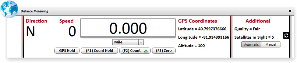
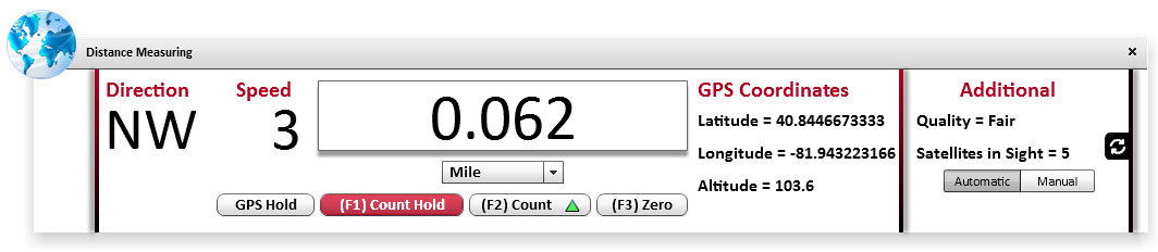
LocationMaster is our easy to use virtual distance measuring instrument (DMI) which can be used
in any vehicle or on foot. Interchangeable with
most GPS antennas. LocationMaster allows quick measuring without any vehicle installation.

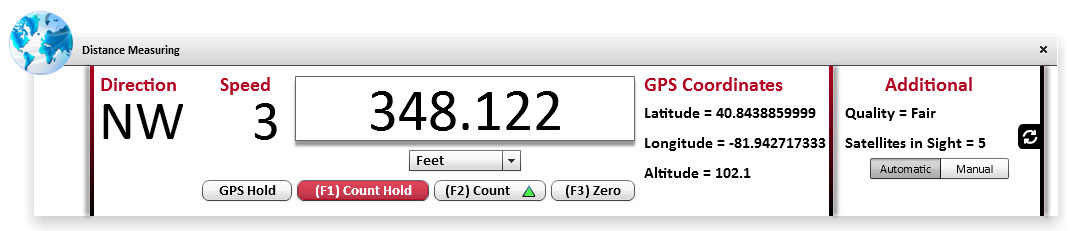


LocationMaster can connect to almost any GPS antenna. Ex: Connected to a QStarz 818XT GPS antenna.
LocationMaster is a virtual DMI that allows you to track your distance traveled, speed, direction, GPS coordinates, and GPS connection quality.
LocationMaster allows you to select between miles, kilometers, and feet traveled. Count hold allows distance traveled to be paused.
LocationMaster can be connected automatically to your GPS antenna.
LocationMaster can be connected manually to your GPS antenna, allowing specific communication port input.
<
>
5 - 5
No vehicle calibration
No hardware installation
Log point can be calculated
in miles, feet, or kilometers
Built directly into MasterSuite allowing all assets to be easily placed with the click of a button
Use while driving in any vehicle or while walking
Easily transferable between any vehicle
Copy latitude, longitude, altitude, and log point
with the click of a button
Interchangeable with most GPS antennas
FEATURES


RETURN TO TOP
SOFTWARE OVERVIEW
CulvertMaster is our easy to use software module
and allows you to inventory, manage, budget, and review all of your culvert data. CulvertMaster
allows in-field inventorying and inspection as well
as office-based post-processing.

Easily view, search, & map
all your culverts. Example:
map all concrete culverts
Mobile Mapping imagery
can be linked to all culverts
Document, track, and report exactly what work was performed. Who, what, why, when, and where.
Easily document, track, and
run reports for all inspections
Quickly take photographs of your culverts with any attached camera
Add, edit, and delete
dictionary items including: material, type, rating, shape, etc.
Easily adjust your GPS coordinates without ever leaving your vehicle
Track many attributes such as: route, GPS, milepoint, material, type, condition, shape, length, etc.
Easily grab and move any culvert on the GIS map which automatically updates GPS coordinates
CulvertMaster pictures are coming soon!
<
>
1 - 1
FEATURES

SOFTWARE OVERVIEW
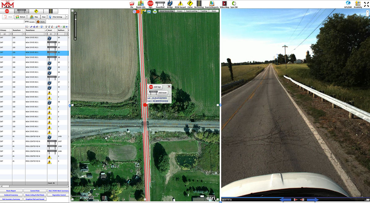
RailMaster is our easy to use software module
that allows you to locate, track, view, and
maintain records for your guardrail, bridge rail,
and right-of-way hazards. RailMaster allows
in-field inventorying and office-based post-processing.


RETURN TO TOP
Easily view, search, & map
all your guardrails, bridges,
and hazards. Example: map
all guardrail needing repair
Mobile Mapping imagery can
be linked to all guardrails, bridges, and hazards
Document, track, and report exactly what work was performed. Who, what, why, when, and where.
Track many guardrail and bridge attributes such
as: GPS, milepoint, post material, guardrail type, assembly end, approach rail, block out type, etc.
Quickly take photographs of your guardrails, bridges, and hazards with any attached camera
Add, edit, and delete
dictionary items including: guardrail type, block out size, guardrail end assemblies, etc.
Easily adjust your GPS coordinates without ever leaving your vehicle
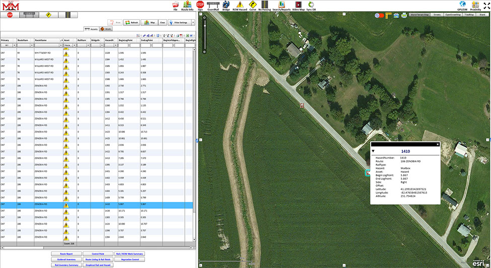
Track many hazard attributes such as: GPS, milepoint,
hazard type (mailbox, rock,
tree, etc), side of road, offset,
work type needed, etc.
Easily grab and move any hazard on the GIS map which automatically updates GPS coordinates
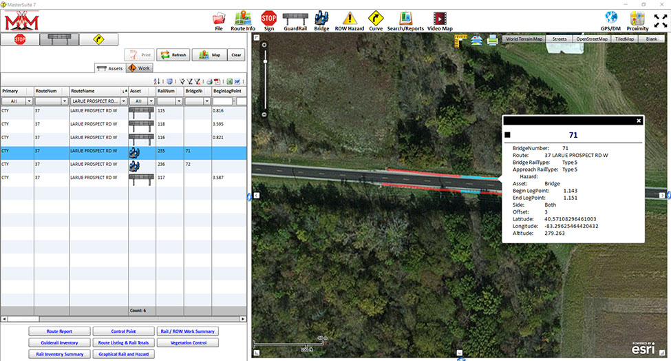
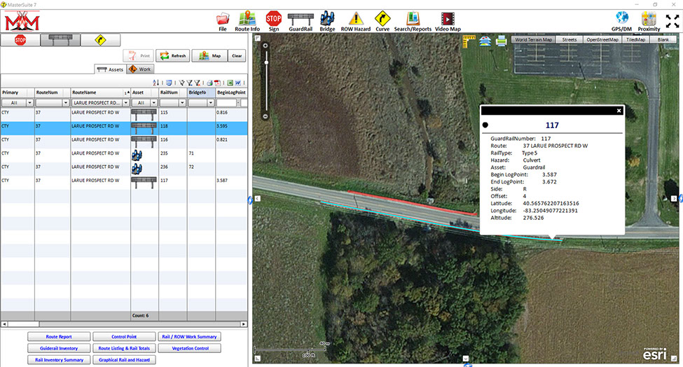

RailMaster allows you view and map all of your guardrail, bridge rail, and hazard assets. Ex: View a specific bridge rail on a specified route.
RailMaster allows you view and map all of your guardrail, bridge rail, and hazard assets. Ex: View a specific guardrail assembly on a specified route.
RailMaster allows you view and map all of your guardrail, bridge rail, and hazard assets. Ex: View a specific hazard on a specified route.
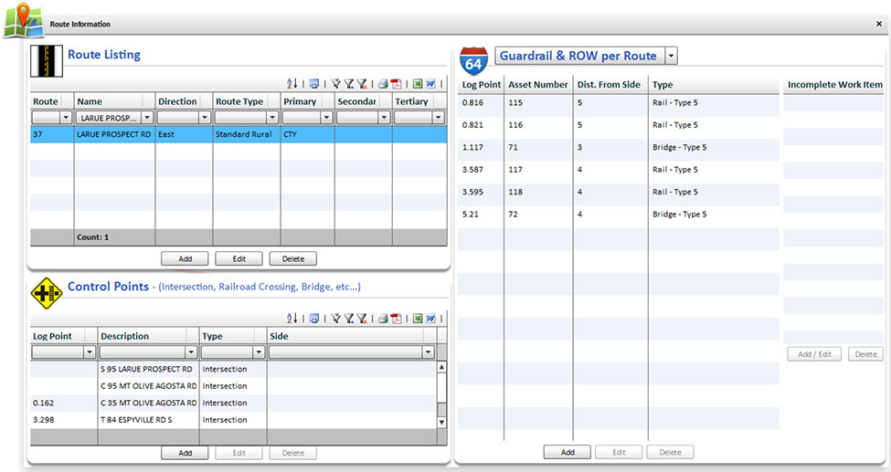
RailMaster allows you view, add, and edit all of your guardrail, bridge rail, and hazards. Ex: View and edit all guardrail attributes.
RailMaster allows you view your routes, control points, and assets simultaneously. Ex: View a specific route's control points and guardrail with the click of a route.
<
>
5 - 5
FEATURES

If you have multiple PC's and are tired of transferring data files,
then "SYNC" is for you. Sync allows you to use the MasterSuite software offline and synchronize your data with all of your coworkers when online.


Sync includes our internet based, WebMaster.
WebMaster allows you to
access your data without installing software.

Sync includes the
opportunity of linking
your esri® ArcMap
software for continual
up-to-date GIS mapping.
RETURN TO TOP

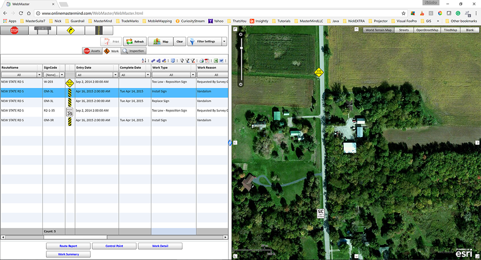
WebMaster allows you to access your asset data (traffic signs, guardrail, hazards, no-passing zones, curves, etc.) from any
internet based computer or tablet without installing software. WebMaster is included with our SYNC component.
No software installation. Access WebMaster from
any internet based
desktop PC or tablet
Easily view, search, and
map all of your asset data from all MasterSuite
modules
View, customize, and print any report from any MasterSuite module, including StripeMaster's no-passing zone graphical reports
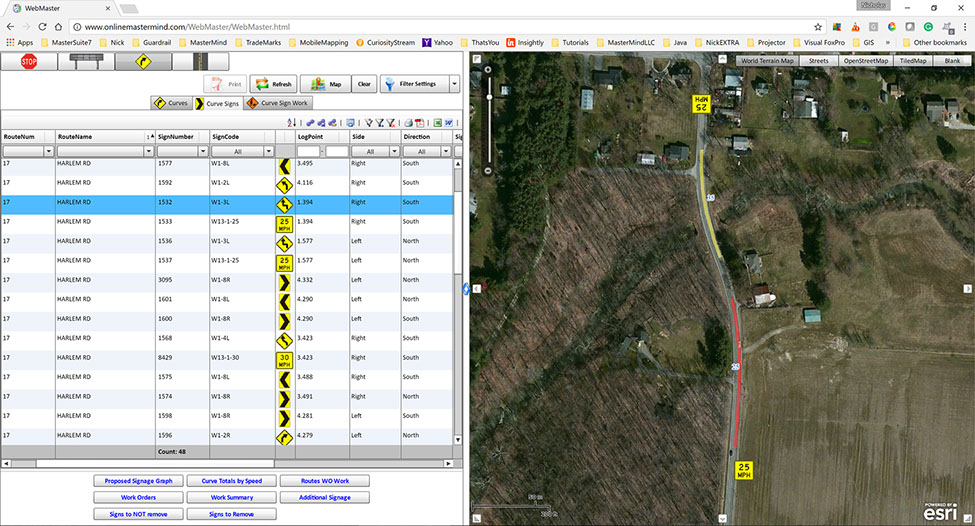

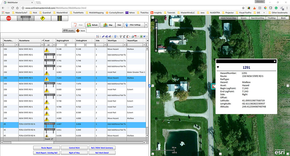

WebMaster allows you to simultaneously view your asset data by way of grid and GIS mapping. WebMaster also allows you to filter your asset data then print your custom and template based reports. Ex: Filter and map your horizontal curves and curve signs on a specific section of road.
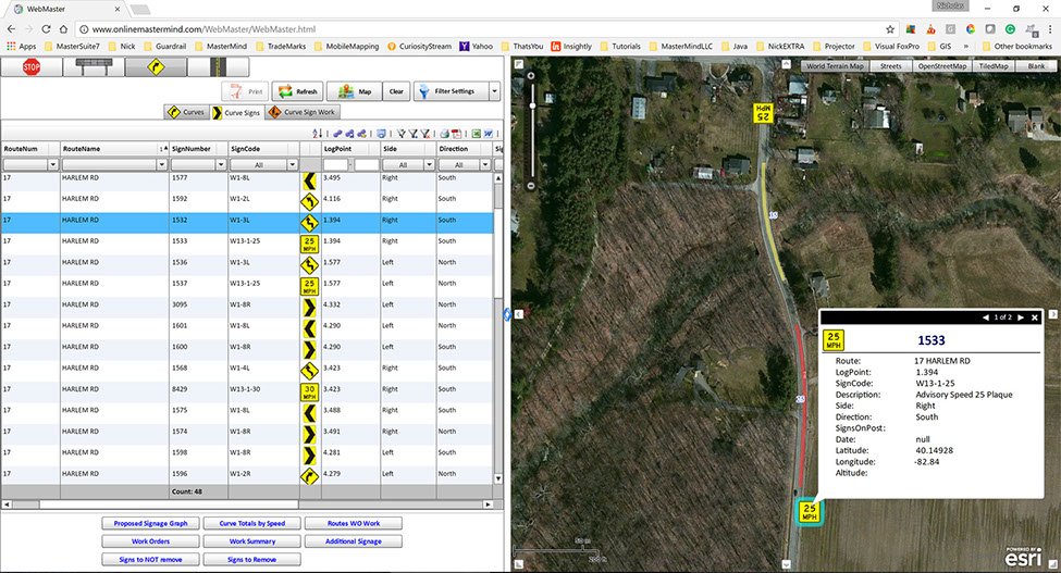
WebMaster allows you to simultaneously view your asset data by way of grid and GIS mapping. WebMaster also allows you to filter your asset data then print your custom and template based reports. Ex: Filter and map your horizontal curves and curve signs on a specific section of a specific road and even "click" on those assets for detailed information.
WebMaster allows you to simultaneously view your asset data by way of grid and GIS mapping. WebMaster also allows you to filter your asset data then print your custom and template based reports. Ex: Filter and map your traffic signs for a selected set of routes.
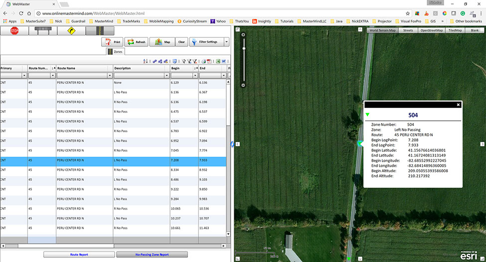
WebMaster allows you to simultaneously view your asset data by way of grid and GIS mapping. Ex: Filter and map your no-passing zones t-marking on a specific road and even "click" on the t-marking for detailed information.
WebMaster allows you to simultaneously view your asset data by way of grid and GIS mapping. Ex: Filter and map your no-passing zones t-marking on a specific road and even "click" on the t-marking for detailed information.2
WebMaster allows you to simultaneously view your asset data by way of grid and GIS mapping. Ex: Filter and map your guardrail, bridge rail, and hazard data and even "click" on the rail or hazards for detailed information.
WebMaster allows you to simultaneously view your asset data by way of grid and GIS mapping. Ex: Filter and map your horizontal curves for a selected set of routes.
<
>
4 - 7
RETURN TO TOP

Easily connect your asset data directly into esri® ArcMap. This allows
your ArcMap data layers to be up-to-date with your continuing asset
data changes. Esri®ArcMap Integration is included with our SYNC component.

Continual up-to-date asset data connecting directly with your MasterSuite data
Read-only connection for increased data security
No need for exporting
or importing Excel files
Data may be filtered and contoured to meet your specific agency needs
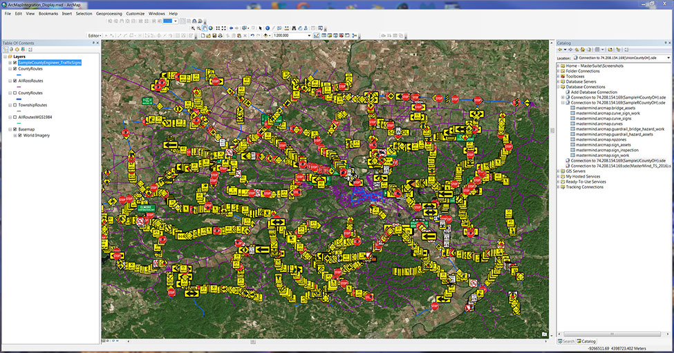

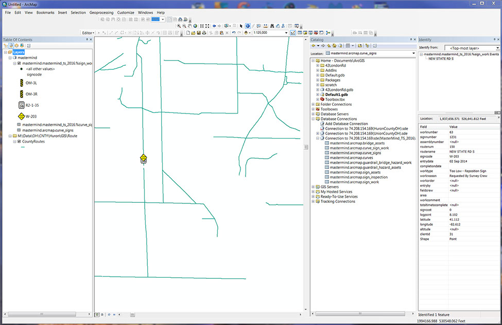

ArcMap integration allows you to easily connect your Sync cloud database and view your read-only asset data. You may then proceed with the data inside of ArcMap however you please. Ex: Link your Sync database and view all your in-field traffic signs overtop your base maps.
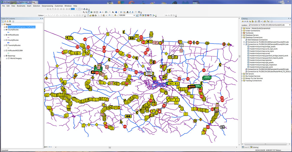
ArcMap integration allows you to easily connect your Sync cloud database and view your read-only asset data. You may then proceed with the data inside of ArcMap however you please. Ex: Link your Sync database and view all your in-field traffic signs overtop your centerline route layers.
ArcMap integration allows you to easily connect your Sync cloud database and view your read-only asset data. You may then proceed with the data inside of ArcMap however you please. Ex: Link your Sync database and view all your traffic sign work history overtop your base maps.
ArcMap integration allows you to easily connect your Sync cloud database and view your read-only asset data. You may then proceed with the data inside of ArcMap however you please. Ex: Link your Sync database and view all your traffic sign work history overtop your centerline route layers.
ArcMap integration allows you to easily connect your Sync cloud database and view your read-only asset data. You may then proceed with the data inside of ArcMap however you please. Ex: Link your Sync database and view all your pavement marking data overtop your basemaps.
ArcMap integration allows you to easily connect your Sync cloud database and view your read-only asset data. You may then proceed with the data inside of ArcMap however you please. Ex: Link your Sync database and view all your pavement marking data overtop your centerline route layers.
<
>
6 - 6
RETURN TO TOP
Tech Support Hours:
Monday - Friday
9am - 5pm EST
We always strive to immediately answer
your questions and concerns, but if delayed
we will always respond within 24-48 hours.

Here at MasterMind we truly care about our customers. We are here to help with all of your questions. We value working with our customers to gain valuable feedback and continuously better our service and software.
MasterMind technical support is only one call or click away.
We're here to help!

RETURN TO TOP
Value Option:
One (1) Year of Technical Support,
Software Updates, & SYNC - $1275.00
Standard Option:
Technical Support Hourly Rate - $100/hr
Cost Per Individual Update - $150.00